
Events: Lake Nockamixon Century - The Greatest Day Out
(2015) I woke up and read the clock: 5:18pm. I had fallen asleep for two hours. It was twelve hours earlier when I had awoken to prepare for the Nockamixon Century. I planned to meet Mike who was riding to the start, and also riding the Century. What lay ahead was a beautiful course that hits its five highest points in the first fifty miles, hits its lowest point of 125 feet above sea level at the metric century mark, hits four covered bridges, and had a high temperature forecast in the nineties. With a departure time of 7:00am, the previous twelve hours before regaining consciousness were full of some of the greatest roads in Bucks County cycling. The Maennerchor Fields provided a large spread for the event with use of parking and its pavilion for registration. The important part of the pavilion would be recognized during the post-ride activities when its shade made the finish even more enjoyable. There was no fanfare at the departure. Many riders were observed departing earlier than 7:00am. Perhaps it was to get a jump on the groups, perhaps it was to get a jump on the clock, perhaps it was to get a jump on the temperature; in any way, riders were eager to get involved in the numerous Bucks County back roads.
The ride’s first Bucks County experience was the immediate ride through Doylestown’s northern section. The route broke west to pursue Peace Valley Reservoir. Many riders were seen up the road at this time as well as behind, but no major group materialized. Many runners could be seen heading northeast on Creek Road, possibly attempting the six-mile loop around Lake Galena.
The route turned northwest up Callowhill Road. It’s a road many cyclists experience in the other direction. This time we headed uphill. A couple turns sent us through the village of Blooming Glen. These roads were foreign in appearance until it was realized they’ve only been ridden from the other direction. Branch Road and Cedarview Drive were previously untouched roads that could now be claimed as ridden. This is where the route picked up Old Bethlehem Road; it’s a blatant cut off road that was snipped in two by the flooding of Lake Nockamixon. It was an uphill drag that had a carrot dangling at the end: the first rest stop. Passing the Lake House Inn, and gaining view of Lake Nockamixon, ‘Rest Stop Ahead’ signs dotted the side of the road. We had been riding just over an hour to get here.

Early morning turns on Branch Road. Photo courtesy Mike McHugh.
It was a quick stop. We topped off the bottles and remounted to continue our path down Three Mile Run Road. The right turn onto Hill Road added to our total climb for the day. The last time I had gone up this road was a couple of years ago when it was in bad shape. Today it appeared to have been recently resurfaced. This was the unofficial start to the shady portion of the course. The only time we would emerge from shade would be the time trial effort down 563.
Roads began to click off at a satisfying rate. Rich Hill turned into Rock Hill. Axe Handle turned onto Thatcher, which turned onto Cider Press. We passed through the first covered bridge, Sheard's Mill Covered Bridge, still under the canopy of shade. These roads felt like wide hallways carved into the countryside. Lines formed only to be scattered again. Just as a rhythm was developed, we made a left onto wide-open 563 and its roomy shoulders. The shoulders had been recently swept making it possible to push the pace harder. Our miniscule group picked up two more riders, a man and woman from Jenkintown, and we trucked toward the second rest stop at a satisfying rate. We were getting to the finish faster this way. Pulls were equal.
At just over two hours, we pulled into the second rest stop for a little bit of nutrition and to top the bottles off. Being a Kermesse event, of course there were Fig Newtons in mass quantities awaiting us. It was our second view of Lake Nockamixon. The Haycock Boat Launch was teeming with people inquiring about the stand up paddling yoga class. All I thought about was our current status of being halfway through the aid stations. Also I thought about the upcoming hills. The lands north of Lake Nockamixon are remarkable in their relentless rolling terrain.
Our train of four remounted and resumed the speedy pace. Top Rock Trail Road, one of my favorite country roads clicked away. This is the road that accesses Haycock Mountain, which was without visitors at that time according to the parking lot. We crossed Haycock Creek’s plank bridge to go deeper into undeveloped land. Stony Garden, Maple, Mink, Winding, Bursonville, these street signs blurred by at an expeditious rate. I was reaching my limit, as evidenced by being constantly fourth in line. Crossing 412 meant the unavoidable rendezvous with the ominously-named Gallow Hills Road.
There is no mercy on this road. It features a sharp left with an extremely steep descending sharper right turn immediately into another left. We were rounding an old cemetary. This is where the steepness kicks in. It is a pure climb. There is no run-up to help deal with the first quarter of the hill. The aforementioned right turn took care of any speed. The three turn combination can rattle any rider especially when the front wheel doesn’t want to turn and the brakes are squeezed even harder. This was our emergence from the wooded area for a bit. We were now in Nockamixon farmlands.
Trauger's Farm is a magnificent feature on the grassy hillside. Its huge wooden white structures with green finish stands in contrast to the blue skies and brilliant green fields around it. It commands the left hillside down Nockamixon Road. It was a nice view to admire at the same time as getting dislodged from the other two riders.

Mike riding along Nockamixon Road with Trauger's farm off to the left. Photo courtesy Mike McHugh.
We continued on through the tiny hamlet of Ferndale – part of the Covered Bridges Ride in the fall. We churned the cranks up Lake Warren back into the cover of trees. We had uttered the phrase, “This is awesome” too many times by this point. This ride, this day out, this event was what the bicycle was made for. We were suffering, but we enjoyed it. As we linked up with Lonely Cottage, we calculated that Ringing Rocks Park was not that far from us. Rest stop number three was close. It was around this time Mike remembered a road in the area he liked. Little did he know we were slated to take it soon. Quickly we rolled up to the Ringing Rocks parking lot and located the tent.
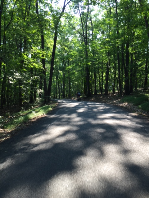
One the shaded roads north of Lake Nockamixon between the first and second rest stop. The shade and remoteness of this area was particularly enjoyable. Photo courtesy Mike McHugh.
Being the farthest rest stop from the start, it was understandable that it was the quietest so far. According to the volunteers, we were visitors six and seven. The couple that rode away from us had opted not to stop. More food was taken on this time in watermelon wedges and more Fig Newtons. Text messages were sent home to chart our progress. The shade was absorbed for a few moments longer prior to topping off the bottles again. Again it took us a little over an hour to get to this station; we were making satisfactory time.

Ringing Rocks Park rest stop. This is the third stop of four. Photo courtesy Mike McHugh.
We rolled out to Bridgeton Hill Road where it was joked to let the descent happen straight into Homestead General Store for coffee. There is only one distraction better in this area, and that is Chestnut Ridge Road, the road Mike had remembered.
Chestnut Ridge Road is a beautiful experience. When combined with Upper Tinicum Church Road, it is a nearly five-mile descent toward the Delaware River. It is heavily shaded which means in the fall it’s an even more beautiful experience. Swamp Creek trickles on the left at a slow pace. The road is windy in places to spot a line and let the bike do its thing. It’s a wonderful ten minutes of riding. Even passing Tinicum Church proper on Sunday morning did not put any cars in our vicinity; We had the road all to ourselves. The euphoria still hanging, we passed through Erwinna Covered Bridge as well as the tiny village of Erwinna, the lowest point on the course. We were close to the Delaware River.
Headquarters turned into Hollow Horn, and we accessed our third covered bridge of the ride, Frankenfield Covered Bridge. This is where I misread the cue sheet stating we were only a mile from the last aid station (We were ten). This section of the course takes on a noticeably different feel. The sight lines down the road are reduced to yards. Thin and numerous trees trunks crowd the road yet provide minimal shade. It wouldn’t be surprising to see horse drawn wagons pass by. The roads feel that old. There are more coniferous trees in this area, too. The thin shade indicated we were making our way into the afternoon sun. We passed through High Rocks State Park and crossed the old wooden bridge over the Tohickon Creek into another park, Ralph Stover Park. This put us on a tough climb. It’s steep, it’s pockmarked, and the miles were taking their toll. The climb up Stump Road is usually a climb thrown in for good measure when group rides are short.

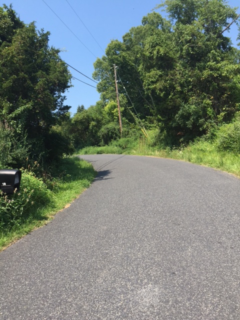
Another example of the peaceful roads near Upper Black Eddy along the Century course. Photo courtesy Mike McHugh.
We turned down Covered Bridge Road that has – you guessed it – a covered bridge at the bottom. We approached Cabin Run Covered Bridge with caution, as oncoming traffic is hard to see. The road itself is bumpy and without uniform. The Tohickon Creek to the right always looks refreshing. The tiny cliffs to the left remind one of the rockiness of Bucks County. The end of the road is adorned with a preserved mill. As a matter of fact, riders drop their right shoulder to duck under the corner of Stover-Myers Mill to continue on Dark Hollow and over the Tohickon for the second time.
It was here we turned left onto Ervin Road and were met by the makeshift memorial for Dan Wilson, a cyclist who tragically lost his life while in that spot while riding over a month prior. Being a writer I sometimes search for words to put meaning behind feeling. I searched for the first few pedal strokes up Ervin but concluded silence would be better. His motocross number can be found attached to a road sign along with a chain wheel leaning against the bottom of it. Mike must've felt the same sentiment. We rode the entire length of Ervin Road in silence out of respect.
We broke into the heat of the day in this area. From Hollow Horn Road and Oak Grove Road onward, the full furnace sensation would be pressing down on us. Mike had been pulling me up these roads since the last rest stop. Only fleeting moments of energy would propel me forward. I thought I would take the front to give him a break only to lose power when pulling alongside. I vowed to take in more food at the final aid station. We also discussed the fact that we had seen no riders for quite some time. At the fourth aid station, the Ottsville Fire Company, we discussed why with the friendly volunteer.
She stated that it was likely many riders were peeling off at the halfway mark to stay closer. The heat was the main factor for not expecting all seventy century riders. While grabbing handful after handful of Fig Newtons, she invited us to ride in the Oktoberfest Ride because of her pumpkin muffins. I had experienced these muffins the year before. The maple cream cheese frosting was almost a hallucinogenic. My stomach ached for those muffins. She also stated we were still riders six and seven to pass through. This final rest stop also meant we were from here on out riding with no shade. It was now a true test of finishing. Luckily the remaining roads are home field stomping grounds. Their familiarity would propel us back to Doylestown.
Park Road climb which accesses South Park Road, the southern road around Lake Nockamixon. Photo courtesy Mike McHugh.
I could narrate the rest of the course. I had seen the pink arrows days prior on my rides. I knew we would take South Park, pass the parched falls of Lake Nockamixon. I knew we would turn left onto Kellers Church Road then onto Sweetbriar, a road I’ve rolled over hundreds of times. I imagined us rolling down Slotter and up Center School, which turns into Hill Road. We accessed Meadow back onto Kellers Church to Creek Road. Creek Road is another beautiful road by the way. It’s another road with a creek on one side and rock formations opposite.
We turned onto Rolling Hills Road. This road is remarkable because of its authentic switchback at the bottom. This is another feature the route can claim. We emerged from the hollow and into farm fields.
Deep Run Road, Log Cabin Road, Applebutter Road - they all contain wide open farm fields with little or no shade to help a rider. What did help in this section was a sudden uptick in cyclists. Our waning legs suddenly had purpose again. We used these riders as bait to chug us along. Mike was still pulling. These were the short course riders whose experience was no easier considering their later start. They were baking just like we were. The worst part was passing my own house around this time. Just over there was a couch, air conditioning, and cans of beer. But then again, how many riders can say he rides past his own house during an event? It may not have been cold, there many not have been cobbles, it may not have been raining, as a matter of fact it was the opposite; we were riding for Flahute status.
We passed through Danboro. The ending was close! I wished it was all downhill. More riders ahead. The water bottles were upended with nothing to provide. We were now racing against the clock. We wanted to finish in fewer than six hours. Turning onto Stoney Lane meant one more turn before the finish. There was a large group of riders going up Stoney Lane. We instinctively pushed harder to get around them. We were going to end the ride on the highest of notes.
Turning onto the final road, the parking cones came into view. No more riders were left to pick off. Without any further fanfare, we turned down the gravel driveway of the Maennerchor and continued straight to the pavilion. I could not look left or right because of severe neck pain. We were sunburnt, we were tired, but most importantly, we had enjoyed every minute of our day out. We had finished in under six hours. We had come into this ride with wavering confidence. We felt the 2015 cycling season had passed us by. This ride salvaged good tidings. All too regularly we said or thought how like cycling should be.
Both Mike and I plunked down at a table. We missed out on the River Horse IPA and settled for amber ale. I lay down on the bench hoping to regain the ability to look somewhere other than straightforward for the remainder of the day. Finishers also received a free Wawa hoagie. Mike then remarkably got back on his bike and rode home.
The Appalachian Trail runs a debatable 2,200 miles up the eastern portion of the United States. People section-hike it or thru-hike the trail. If one were to shrink the trail down to a proportionate equivalent in Bucks County, the Nockamixon Century route would serve a similar purpose. The ride passed through noticeably different zones of Bucks County. What it also does is highlight some lesser-known features of Bucks County. If one is expecting visitors, it may behoove him to follow the Century route to show people this area's offerings.
After loading the car and heading home by steering and shifting with my fingertips, fatigue set in. I tried to cool off with a shower and lay on the bed just to ‘rest my eyes.’ I woke up at 5:18pm with burning lungs, heavy legs, and sunburnt skin. I also woke up with the biggest sense of satisfaction to have shared one of the greatest rides ever in one of the best locations for such a challenging event. Twelve hours can do that.
Kermesse Sport offers two more rides this season: The Gran Fondo New England on October 4th in Providence, Rhode Island, and the Oktoberfest Ride on October 25th in Collegeville, PA.

